In East Nara Nabari, there are many mountain climbing and hiking spots that especially beginner or intermediate level hikers can enjoy. Today I would like to share a photolog about the cross-border trek I took in the early summer. The cross-border here doesn’t mean a border between countries, but between prefectures; Mie and Nara. If you’re a hiker and not familiar with the area, I hope this post will make a good opportunity for you to explore there.
I took the following route for two days and one night with my friends in late May when the weather was mild. Since it had different start and endpoints, I asked another friend to drive us to the start point and to pick us up at the endpoint the next day.
Here are the itineraries. The difficulty level is about beginner to intermediate.
Full Itinerary
- Route
- Day 1: Omata → Myojindaira → Mt. Myojindake → Mt. Hinokizuka-okumine → Hinokizuka Mound → Myojindaira ( GPX data)
- Day 2: Myojindaira → Mt. Kunimi → Mt. Isetsuji → Mt. Kumogase → Takami Pass (O-toge) → Ko-toge → Takami-sugi → Takasumi Onsen ( GPX data)
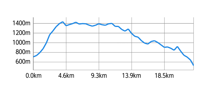
- Activity Log
- Distance: 24.1km
- Elevation Difference: 994m
- Elevation Gain/Loss: 2325m/2564m
Day 1: Omata - Myojindaira - Hinokizuka Mound - Myojindaira
This page covers the trek on the first day until we stayed overnight in our tents.
We started our trek from Omata parking lot, Higashi Yoshino Village in Nara Prefecture. We first went to Myojindaira to set up our tents. After we lightened our loads, we headed again. Crossing Mt. Myojindake on the border, we arrived at Hinokizuka Mound on the Mie Prefecture side. Then we went back to our base camp, Myojindaira, to stay overnight.
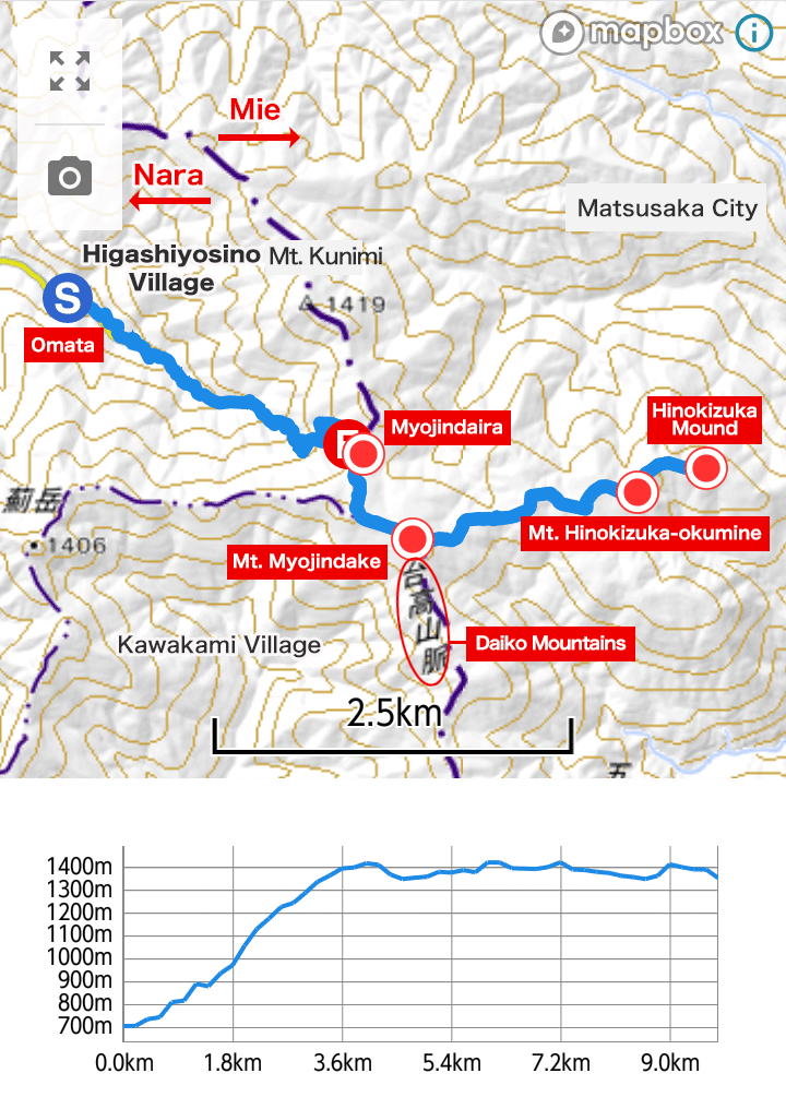
- Route
- Omata → Myojindaira → Mt. Myojindake → Mt. Hinokizuka-okumine → Hinokizuka Mound → Myojindaira ( GPX data)
- Activity Log
- Distance: 11.2km
- Elevation Difference: 738m
- Elevation Gain/Loss: 1331m/788m
Click/tap on the photos below for captions.
Omata to Myojindaira
We drove to the Omata parking lot in Higashiyoshino Village in the eastern part of Nara Prefecture (see map below) and started trekking at 10 a.m. On the trail were fallen trees, but we continued to hike, avoiding them. Shortly after, Myojin Falls appeared. You find crystal clear water flowing through Higashiyoshino, where the dragon, a water deity, has been worshipped since ancient times.


Myojindaira to Mt. Myojindake
We arrived at Myojindaira in about two hours. We were relieved to see the open landscape spreading out in front of us. The first thing we did here was to set up our tents for our overnight stay. Then we had our lunch. Myojindaira is quite popular among local campers, but I have to remind you that it’s a primitive campground with no toilets. After lunch, we walked up to Mt. Myojindake. In about 20 minutes, we reached its summit.


Mt. Myojindake to Mt. Hinokizuka-okumine
At Mt. Myojindake, the white azaleas were in full bloom, and everyone was taking pictures of them. After enjoying the beautiful scenery for a while, we headed east to Mt. Hinokizuka-okumine on the Mie Prefecture side. It’s the highest peak in Mie except for the mountains on the border, at an altitude of 1,420m. The view at its top is spectacular, and you can see far into the distance.


Mt. Hinokizuka-okumine to Hinokizuka Mound
As we had plenty of time left, we decided to hike to Hinokizuka Mound. Then we headed back to our base camp, Myojindaira.


")
Tent Camping at Myojindaira
We arrived at Myojindaira at around 4:00 p.m. The days were long because it was May, so we leisurely prepared dinner, fetching water and lighting a bonfire. Watching the sky gradually turn orange, we had a blissful time sharing drinks with good friends. We had brought bottles of local sake with us specially for the night. The taste of sake in this situation surrounded by rustic nature is so different from when you drink it in town. It was totally worth the weight of carrying those bottles with us.
It was getting late, and we had a bit too much of sake. We went to bed at 9:00 p.m. in each tent, wondering if we would be okay tomorrow.


Myojindaira is also worth a visit during the winter, as rime ice (hoarfrost) can be seen when the condition is good. You can enjoy a completely different view from that of early summer.
This trek was done before the COVID-19 pandemic.
- Related blog post
- Cross-border trekking in East Nara Nabari: Day 2
- Omata parking lot
- Location: Please refer to the map below
- Access: About 1 hour and 10 minutes from Hari Exit of Meihan Expressway / About 1 hour and 20 minutes from Kintetsu Nabari Station (There are several car rentals near the Station)
- Takijiman Brewery
- Official website Facebook Twitter